What Is a Microburst? The Storm That Pushed Down Delta 191
While its name sounds like a short lived storm, the destruction of a microburst is quite the opposite. Learn more about these severe weather storms.
Quick Reference
- What it is: a small but extremely intense column of sinking air inside a thunderstorm that hits the ground and spreads outward at high speed.
- Size: 2.5 miles or less in diameter, lasting 5 to 15 minutes from contact to dissipation.
- Wind speed: 60 to 100+ mph at the surface, comparable to an EF1 tornado but moving outward in straight lines instead of rotating.
- Two types: wet microburst (heavy rain at the surface) and dry microburst (rain evaporates before reaching the ground, no visible precipitation).
- Aircraft danger: several fatal crashes attributed to microbursts, including Delta Air Lines Flight 191 at Dallas-Fort Worth on August 2, 1985 (137 killed). All commercial aircraft now carry on-board wind shear detection systems as a result.

The word “microburst” sounds small. The damage is not. A microburst can level a barn, snap a row of mature trees in half, push a small plane out of the sky, and produce wind speeds rivaling an EF1 tornado, all in a circle a couple of miles across, all in less time than it takes to drink a cup of coffee. Microbursts are the reason every commercial aircraft flying through U.S. airspace today carries on-board wind shear detection equipment. They are the reason a clear-day approach to a Texas runway in August can turn deadly without warning. Here is what a microburst actually is, how it forms, why it is so much more dangerous than its size suggests, and how aviation and forecasting changed after the worst microburst-related crash in U.S. history.
What a Microburst Actually Is
A microburst is a downburst (a column of rapidly sinking air from a thunderstorm) that is unusually small and unusually intense. The defining size threshold is 2.5 miles in diameter at the surface. Anything larger is called a “macroburst.” The microburst label is what Tetsuya “Ted” Fujita, the Japanese-American meteorologist who developed the F-scale tornado intensity rating, coined in the late 1970s after studying a series of unusual aircraft accidents. He used “micro” in the literal sense: a small, contained event distinct from larger downburst patterns.
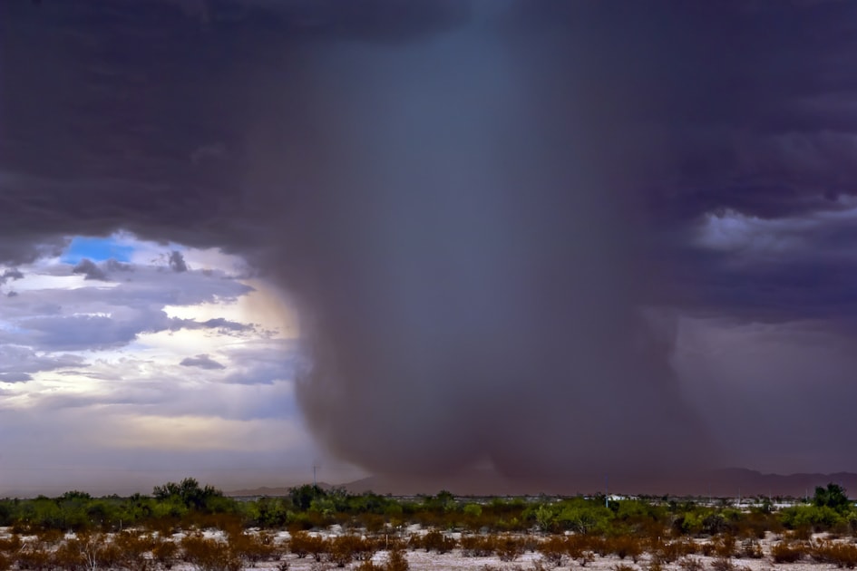
The mechanism is a mass of cold, dense air inside a thunderstorm that suddenly loses its support and falls. As the air column reaches the ground, it cannot keep falling, so it spreads outward in all directions like water from a garden hose hitting a sidewalk. The outward-spreading wind is what does the damage. At the contact point, vertical winds can hit 60 to 100 mph briefly. As the column spreads outward, horizontal wind speeds at the surface can reach the same range, persisting for 5 to 15 minutes before friction slows them down.
Wet vs. Dry Microbursts
The two main types of microburst differ in whether the falling rain ever reaches the surface, and the difference matters for both detection and prediction.
- Wet microburst: the storm contains enough moisture that heavy rain reaches the ground inside the burst column. Most common in the humid Southeast and along the Gulf Coast. The visible signal is a sudden, intense burst of rain at the moment the wind hits.
- Dry microburst: the rain falls into a layer of dry air below the cloud and evaporates before reaching the ground. Most common in the arid Southwest, the Great Basin, and the Front Range of the Rockies. The visible signal is a “virga” trail (rain shafts that fade out before touching down) followed by a sudden, severe wind at the surface, often with no visible rain at all.
Dry microbursts are particularly dangerous for aviation. The pilots see the storm cell on radar, the storm appears to be putting only light rain over the airport, the surface winds appear calm, and then within seconds an invisible column of air slams into the runway with damaging force. The Delta Flight 191 crash at Dallas-Fort Worth in 1985 was a classic wet microburst case (rain plus wind shear), but the dry microbursts of the Western U.S. are arguably trickier because there is no visible precipitation to alert the pilot to the storm’s intensity.

How a Microburst Forms
Microbursts come from thunderstorms, but not all thunderstorms produce microbursts. The setup that does produce them goes through a sequence:
- Strong updraft. Warm, moist air rises rapidly within the storm, lifting water droplets and ice crystals high into the atmosphere. The stronger the updraft, the higher the moisture goes and the colder it becomes.
- Heavy water/ice load aloft. The moisture and ice accumulate at the top of the storm, suspended by the updraft. The storm is now carrying tons of water at altitudes of 30,000 feet and above.
- Updraft collapses. When the load becomes too heavy for the updraft to support, or when the updraft weakens, the moisture begins to fall.
- Evaporation cooling (in dry microbursts). As the rain falls into a layer of dry air, some evaporates. Evaporation absorbs heat, cooling the surrounding air and making it denser. The denser, colder air falls faster.
- Acceleration toward ground. The cold, dense column accelerates downward, pulling more cold air with it. By the time it nears the surface, vertical wind speeds can hit 60 to 100 mph.
- Surface impact. The column hits the ground and cannot keep falling. The air spreads outward in all directions, producing a circular pattern of damaging wind.
The whole sequence, from updraft collapse to surface impact, takes only a few minutes. That short timeline is why microbursts are difficult to forecast minute-by-minute and why the warning lead time is much shorter than for tornadoes (often 1 to 3 minutes versus 15 to 30 for tornadoes).
The Three Stages of a Downburst
Once a microburst is on the ground, it goes through three distinct stages over the next 10 to 15 minutes:
- Contact stage. The sinking air column makes initial contact with the surface. This is the highest-wind, most-damaging phase. The damage radiates outward from a single point of impact.
- Outburst stage. The air spreads outward from the contact point, curling upward at the leading edge as it encounters more stable surrounding air. Wind speeds remain high at the leading edge for 5 to 10 minutes.
- Cushion stage. Wind speeds at the original contact point begin to weaken as the outflow exhausts itself. The leading edge continues outward but slows. Friction with the surface and surrounding air gradually dissipates the burst.
By the end of the cushion stage, the microburst is gone. The damage left behind is the visible record. Cleanup almost always takes longer than the storm itself; a 10-minute microburst can produce hours or days of debris removal.
Microburst Damage vs. Tornado Damage
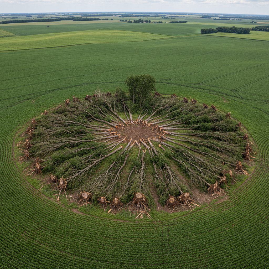
From the ground, microburst damage and tornado damage can look superficially similar. Both can level trees, take roofs off houses, throw vehicles around, and snap utility poles. From the air, the two leave very different fingerprints.
- Tornado damage: debris and downed trees scattered in chaotic, swirling patterns. Trees fall in different directions in different parts of the same yard. Vehicles and structural pieces are sometimes lifted and dropped far from their origin point.
- Microburst damage: debris and downed trees fall in straight, radiating lines from a single point. The damage pattern looks like the petals of a flower (or the spokes of a wheel) centered on the contact point. Trees on opposite sides of the burst fall in opposite directions, but every tree falls in line with the radial direction from the center.
This pattern is how National Weather Service damage assessors distinguish the two after a storm. A team walks the damage zone, maps the direction of fallen trees, and looks for the signature: scattered/swirling means tornado, radial/straight means microburst. The distinction matters for the official record, the EF-scale rating, and any rebuilding code or insurance documentation that follows.
Delta Flight 191 and the Wind Shear Revolution
The single event that changed how the U.S. forecasts and detects microbursts was the crash of Delta Air Lines Flight 191 at Dallas-Fort Worth International Airport on August 2, 1985. The flight, a Lockheed L-1011 inbound from Fort Lauderdale to Los Angeles via DFW, was on final approach when it encountered a wet microburst from an isolated thunderstorm sitting just north of the runway. The aircraft entered the burst at about 800 feet above ground level. Within seconds, the wind shear (a rapid shift from headwind to tailwind as the plane crossed the burst column) caused the airspeed to drop below the level needed to maintain lift. The aircraft struck the ground a mile north of the runway threshold, killed 137 people (134 on the plane and 1 on the ground), and left 29 survivors.
The NTSB investigation found that the crew had decided to fly through the storm cell rather than divert, and that the aircraft’s onboard equipment at the time could not detect the wind shear that caused the loss of lift. The combination (pilot decision, cell intensity, lack of detection) was the proximate cause. The recommendations that followed transformed commercial aviation:
- NASA’s Langley Research Center developed onboard Doppler radar capable of detecting wind shear in the storm cell ahead of the aircraft.
- The FAA mandated that all commercial U.S. aircraft carry onboard wind shear detection equipment, with the deadline staggered through the early 1990s.
- The FAA installed Terminal Doppler Weather Radar (TDWR) systems at major U.S. airports, which scan the airspace around runways for microburst signatures every 30 to 60 seconds.
- Pilot training programs added microburst awareness, microburst escape maneuvers, and a strong bias toward going around or diverting when storm cells are near the runway.
The U.S. has not had a fatal commercial microburst-related crash since US Air Flight 1016 at Charlotte-Douglas in July 1994 (37 killed), which was itself the last accident before the full TDWR network came online and onboard wind shear systems became standard. The lesson of Delta 191 is the underlying reason the modern flying public is rarely exposed to microburst risk on approach. The technology and the training have closed the gap.
Detecting a Microburst with Doppler Radar
Modern Doppler radar can detect microbursts with reasonable confidence by reading the velocity field around a thunderstorm cell. The signature is a small region of strongly diverging wind: a tight pocket of pixels showing wind moving in opposite directions on either side of a single point. That pattern, called a “divergence couplet,” is the radar fingerprint of a downburst column hitting the ground and spreading outward. The lead time is short (often only 1 to 3 minutes between detection and surface impact), but it is enough for an alert to reach pilots on approach and ground operations on the airfield.
For inland regions without TDWR coverage (most of the U.S. outside the major airport hubs), the National Weather Service NEXRAD network is the primary microburst detection system. Lead times are similar but the warnings are usually broadcast as severe thunderstorm warnings with embedded text mentioning damaging wind potential, rather than separate microburst alerts. For more on how the NEXRAD network reads storms, see our Doppler radar piece.
When and Where Microbursts Happen
Microbursts are summer storms in the U.S., overwhelmingly. The combination of strong solar heating, abundant moisture (or, in the dry-microburst zones, abundant evaporation potential), and unstable atmospheric profiles peaks in June, July, and August. Some patterns by region:
- Southeast and Gulf Coast: wet microbursts dominate. Late afternoon and early evening are peak windows. Florida produces more wet microbursts than any other state, often as part of routine summer thunderstorm activity.
- Front Range of the Rockies (Colorado, New Mexico): dry microbursts dominate. Storms move off the high terrain in late afternoon, drop their precipitation into the dry layer over the plains, and produce intense surface winds with little visible rain.
- Great Plains: a mix of both, depending on the moisture profile of the day. Severe weather outbreaks often produce both microbursts and tornadoes from the same storm complex.
- Northeast and Midwest: wet microbursts as part of summer thunderstorm complexes. Less frequent than in the Southeast but capable of producing major localized damage when they hit.
- Pacific Northwest: rare, but possible during the small thunderstorm season in late summer.
Coastal zones, mountain valleys, and open plains are all possible microburst territory. The common thread is the thunderstorm overhead. If a strong summer storm is moving through, the possibility of a downburst is part of the threat profile, alongside lightning, hail, and (in some setups) tornadoes.
What to Do If a Microburst Hits
Microbursts arrive with little warning, and the safe response is the same as for severe thunderstorms generally: get inside, get away from windows, and stay there until the storm has passed.
- Indoors: move to an interior room on the lowest floor. Avoid windows. Stay away from large unsupported roof spans.
- Outdoors: get inside if possible. If not, get into a vehicle (better than nothing) and stay buckled. Avoid trees, power lines, and large open spaces.
- Driving: if a microburst hits while you are on the road, pull over, stop, and stay in the vehicle. Do not park under a tree or near power lines. Watch for blown debris.
- Boating: microbursts at sea or on a lake can swamp small craft in seconds. Get to shore at the first sign of an approaching storm cell.
The good news is that microbursts are short. A 10-minute window of severe wind followed by ordinary thunderstorm conditions is the typical sequence. The damage looks dramatic, but the surface conditions return to normal quickly once the burst exhausts itself. For more on safety guidance during severe summer storms, the National Weather Service maintains a comprehensive microburst and downburst safety reference with regional data and historical case studies. For the long-range outlook on which weeks are likeliest to bring severe summer storms in your region, see the Farmers’ Almanac long-range forecast.
For more on the storm setups Doppler radar tracks alongside microbursts, see our lake-effect snow piece. A microburst is small, brief, and intense. Treat it like the localized severe-wind event it is, and the damage stays a story rather than a tragedy.

Frequently Asked Questions
How big is a microburst?
2.5 miles or less in diameter at the surface, by definition. Larger downbursts (3 miles and up) are called macrobursts. The “micro” in the name refers to the size, not the intensity.
How fast is the wind in a microburst?
Surface wind speeds in a microburst commonly reach 60 to 100 mph, comparable to an EF1 tornado on the Enhanced Fujita scale. The most intense microbursts have produced winds over 150 mph, in line with EF3 tornado damage.
How long does a microburst last?
5 to 15 minutes from initial surface contact to dissipation. The contact stage (highest winds at the impact point) lasts only a couple of minutes; the outflow continues spreading for the rest of the lifecycle.
How is a microburst different from a tornado?
A tornado rotates and the rotation is the damage mechanism. A microburst does not rotate; it pushes air outward in straight lines from a single point. The damage patterns are visibly different from above: tornadoes produce chaotic, swirling debris paths; microbursts produce radial, fan-shaped damage zones.
Can microbursts happen without rain?
Yes. A “dry microburst” forms when the rain falling from a storm evaporates before reaching the ground, but the cold sinking air column reaches the surface anyway. Dry microbursts are most common in the arid Southwest and Front Range. They are particularly dangerous because there is no visible precipitation to alert you to the storm’s intensity.
Why are microbursts dangerous to aircraft?
An aircraft entering a microburst encounters a rapid shift from headwind to tailwind as it crosses the burst column. The change in relative airspeed can be 40 to 80 mph in a few seconds, which can drop the aircraft below the speed needed to maintain lift. Several fatal commercial crashes have been attributed to microburst-related wind shear, including Delta Flight 191 in 1985.
When do microbursts happen?
Almost always during summer thunderstorms (June, July, August) in the U.S. Late afternoon and early evening are peak windows, when daytime heating has reached maximum and storm cells are at their strongest.


Jaime McLeod
Jaime McLeod is a longtime journalist who has written for a wide variety of newspapers, magazines, and websites, including MTV.com. She enjoys the outdoors, growing and eating organic food, and is interested in all aspects of natural wellness.
- Jaime McLeod

- Jaime McLeod
- Jaime McLeod
- Jaime McLeod


Years ago I was staying with a friend after suffering a house fire, everyone else was gone and it was storming. I was on my phone with one of my adult children when I heard this sudden roaring sound. The wind was bending trees as I looked out the door. Boom! I yelled “OMG, the neighbor’s roof just blew off!” I quickly ended my call and took off. Several other neighbors ran too. The house was occupied by a 80+ woman who lived alone. She was fine, never heard a sound (hard of hearing), she thought a large truck went by. A few male neighbors tacked tarps over what was left of her roof until she could get a roofer there. I’ve never experienced something like that since but was hit by the June 29, 2012 derecho. My property had a tornado (ef 0 or 1) that twisted trees around, laid 5 trees on a neighbor’s house and did damage other places.
Oops forgot… It was determined that a micro burst caused the damage to her roof.
I’m living here in AZ now. About 7 years ago we experienced a micro burst storm. It was Amazing! It lasted for about 15-20 mins, but this one traveled a short distance. Starting with light wind and rain spatters, within a minuter or two it was very heavy rain mixed with hail that was blowing horizontal to the ground, that lasted for another couple of minutes, then we experienced the ‘eye’, no wind no rain just the water dripping which lasted for an other min or two, then the wind started again but this time from exactly the OPPOSITE direction with the rain and hail, again horizontal! Then it died off. All totaled it lasted about 15-20 minutes as I said earlier. Holes were driven into the watermelons, squash, melons, etc., where the hail struck them and the rest of the crops were flattened.! As close as 1/4 mile away they only saw the cloud, but got no rain or hail, or even the winds, just a breeze, nothing but sunshine.
June 23,2015 Southern New Jersey hit by microburst much devastation
Microbursts, especially a report of a macroburst are extremely rare throughout much in the Tri-state areas: the boroughs of New York City, Long Island, Lower Hudson Valley in southeastern New York and Gold Coast and Greater New Haven in southwestern Connecticut, including Gateways region in northeastern New Jersey.
Suddenly interesting and powerfully dangerous, based on the NWS (National Weather Service) in Upton, NY, contains recent significant severe weather events involves with the official reports of microbursts, including a macroburst that occurred in the Tri-state areas with little or no warnings at all.
For instance, here’s the lists of recent dates that demonstrates the example of the events that occurred in the Tri-state areas:
2008:
(1)June 16th, 2008 – Northport, NY microburst/straight-line wind damage; according to Storm Events Database, a microburst occurred in the early evening with peak winds estimated from 60 to 70 mph that down at least 50 trees, blocked one road.
(2)August 6th, 2008 – Harrington Park, NJ microburst/straight-line wind damage; according to the NWS, a microburst occurred in the morning with peak winds estimated around 90 mph that downed multiple large tree branches and few large trees, caused damage to 5 to 10 houses and some parked cars.
(3)August 7th, 2008 – Stratford and Milford, CT microburst/straight-line wind damage; according to the NWS, a microburst occurred in the early evening with peak winds estimated 75 mph that downed dozens of trees and power lines, some damaged vehicles and houses. Additional damages includes shingles were torned off a house and a large fiberglass flagpole split in half.
(4)August 15th, 2008 – Mount Vernon, NY microburst/straight-line wind damage; according to the NWS, a microburst occurred in the late afternoon with peak winds estimated from 65 to 75 mph that downed large trees, with the most significant damage occurred in Packman Avenue.
2009:
(1)July 7th, 2009 – Yonker to Eastchester, NY microburst/straight-line wind damage; according to the NWS, a microburst occurred in the late evening with peak winds estimated 100 mph (revised) that downed numerous large trees that fell on structures, power lines and car with the worst damage reported around Trevor Park in Hudson River Museum with few shingles being torned off in the roof and reports of downed large trees in Oakland cemetery. From Bronxville to Eastchester/Tuckahoe to Mount Vernon reported reported peak winds estimated from 70 to 80 mph with countless reports of downed trees, including a large tree fell on powerlines that snapped a telephone pole in half.
(2)July 31st, 2009 – Naugatuck, CT microburst/straight-line wind damage; according to the NWS, a microburst occurred in the mid-afternoon with peak winds estimated about 95 mph that downed numerous trees, including some healthy trees being reported snapped about one-third of the way down from the top.
(3)August 18th, 2009 – Central Park, NY microburst/straight-line wind damage; according to the NWS and Storm Events Database, a microburst occurred in the mid-evening with peaks estimated over 80 mph as the New York City OEM (Office of Emergency Management) reported few more than hundred trees in Central Park, with the most significant tree damage occurred in western Central Park between 90th and 100th street. Numerous other trees were reported down in Manhattan, damaged several autobmobiles in which consisted of few more than five hundreds of trees being reported down.
To be continue…..
While storm chasing several years ago, my friend Don & I actually watched a microburst a few miles from where we were. It lasted about 30 seconds and as it hit a dirt field, We could see the dust being kicked up by the microburst. That was the only microburst I ever observed.
we had one about five years ago . we lost 29 trees including all our apple trees which were heavy with fruit. in the area effected thousand of trees were knocked over or broken the weather service said because our small/new apple trees were knocked over and broken the believe the wind was well over 100 mph. to this day on golf course next to us there are still trees being cleaned up. and still pieces of the neighbors roof driven into the siding on our garage. it only lasted a minute. there was a big roar my husband and i both said at the same time what the h-ll is that. trees were on houses and cars the power was out for 5 days .
Had one last thursday. Still cleaning up after 5 days! Cost ? very expensive.
My thing to learn for the day. I swear a microburst visited neighborhood last week. Leaves and branches all over the place but no tornado report.
Very interesting. I’ve allways wondered how these work since seeing the smoke from the downed Airliner at DFW in the 90’s.