
Farmers’ Almanac 2026–2027 winter forecast calls for a season of snow, sleet, and surprises. When will it snow? Here is your extended winter storm weather forecast with 2026–2027 weather predictions. See detailed long range forecast for your region in 3-day blocks (members-only).
Snow, Sleet, and Surprises
Bundle up and brace yourself. According to the Farmers’ Almanac, winter 2026–2027 is shaping up to be a season of sharp contrasts. El Niño is expected to remain an important influence through the heart of the season, favoring wetter-than-normal conditions across much of the southern United States, while the North sees quick cold snaps, brief snowy periods, and frequent milder breaks.
The season officially begins with the winter solstice on December 21, 2026. See our Fall 2026 Weather Forecast. See 20 early signs of a harsh winter coming.
Regional Outlook
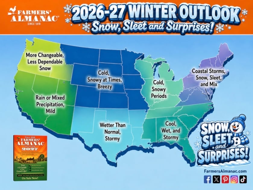
Winter 2026–2027 may be defined by contrasts: an active and wet southern storm track, quick bursts of snow and cold across the North, and a particularly unpredictable mix of precipitation in the Northeast.
For 2026–2027, a very active southern storm track is expected to bring heavier-than-normal precipitation from California and the Southwest eastward through Texas, the Gulf Coast, and the Southeast, with sleet, freezing rain, or heavy, wet snow possible whenever colder air surges in. A second storm path may run along the Eastern Seaboard, bringing rain, wintry mixes, and snow from the mid-Atlantic into New England. Across much of the West, northern Plains, Upper Midwest, and Great Lakes, temperatures should average near normal overall, but that does not mean a mild winter: expect fast-moving clippers, sudden cold snaps, and brief snowy periods, often interrupted by milder breaks.
Zone-by-Zone Forecast
Zone 1: Northeast and New England
States: NY, VT, NH, ME, MA, CT, RI, PA, NJ, DE, MD, DC
The Northeast may face one of the season’s most complicated winter patterns. A second storm path may guide weather systems along the Eastern Seaboard, and because temperatures may frequently hover near freezing, small shifts in storm tracks and temperatures could make the difference between rain, sleet, freezing rain, and accumulating snow. Coastal communities, including New York City and Boston, could receive more rain or mixed precipitation, while inland areas, including the interior and higher elevations of Pennsylvania, Vermont, New Hampshire, and Maine, may be hit by several rounds of heavy, wet snow, particularly during January and February. Residents should be prepared for forecasts to change quickly as storms approach.
Zone 2: Great Lakes and Midwest
States: OH, MI, IN, KY, IL, WI
The outlook for the Great Lakes and Midwest is cold, with snowy periods. Temperatures should average near normal overall, but that does not mean winter will be mild. Chicago, Indianapolis, and the rest of the zone should expect fast-moving clippers, sudden cold snaps, and brief snowy periods, although milder breaks may frequently interrupt the wintry weather. Farther north, the Great Lakes could see sudden snow squalls, blustery winds, and bursts of bitter cold, and snowbelt communities downwind of the lakes should be ready for them.
Zone 3: Southeast
States: TN, VA, WV, NC, SC, GA, AL, MS, FL
The Southeast lies along this winter’s active southern storm track, and the outlook is cool, wet, and stormy. Wetter-than-normal conditions are the headline story, with frequent storm systems and muddy fields. Snow is not the primary threat for most of the Southeast, but when colder air surges in and meets that moisture, some storms could produce sleet, freezing rain, or heavy, wet snow. Atlanta residents should keep an eye on the forecast whenever a cold surge coincides with one of the season’s frequent storms. Florida trends cooler and wetter than usual, and northern Florida may see occasional surges of cold air.
Zone 4: North Central
States: MO, IA, MN, ND, SD, NE, KS, CO, WY, MT
The outlook for the North Central region is cold, snowy at times, and breezy. Temperatures should average near normal overall, but the middle of the country may see frequent swings between thawing and freezing, creating rapidly changing road and field conditions. Minnesota, North Dakota, South Dakota, and Montana could see sudden snow squalls, blustery winds, and bursts of bitter cold. The northern Plains could turn drier at times when the southern storm track dominates, though brief but intense periods of cold, wind, and snow remain possible. In the mountains, the southern Rockies, including Colorado’s ranges, may fare especially well for snowfall. Across the Plains, expect fast-moving clippers and brief snowy periods.
Zone 5: South Central
States: AR, LA, OK, TX, NM
Zone 5 sits along this winter’s active southern storm track, and the outlook is wetter than normal and stormy. Frequent storm systems are expected, and when colder air surges in and meets that abundant moisture, some storms could produce sleet, freezing rain, or heavy, wet snow. Dallas, Oklahoma City, and Tulsa should monitor the forecast closely during cold intrusions. Louisiana, Arkansas, and southern Texas should watch for frequent storm systems, heavier-than-normal precipitation, and muddy fields. New Mexico’s southern desert shares in the wet pattern, and its mountains, part of the southern Rockies, may fare especially well for snowfall.
Zone 6: Northwest
States: WA, OR, ID
The Pacific Northwest may experience a more changeable and somewhat less dependable snow season. Milder stretches mean precipitation in the valleys will often fall as rain rather than snow, and snow in the Cascades, which provide critical spring and summer water supply for the region, may be less dependable than usual. Seattle and Portland should expect a changeable winter, with mild, damp stretches between colder spells. Skiers planning Cascade resort trips should plan for variable conditions.
Zone 7: Southwest
States: CA, NV, UT, AZ
The outlook for the Southwest is mild, with rain or mixed precipitation. The active southern storm track is expected to bring heavier-than-normal precipitation from California and the Desert Southwest eastward, so Los Angeles, San Diego, and Phoenix should watch for frequent storm systems and a wetter-than-normal winter. Nevada’s lower deserts should stay mild.

Buy Your 2027 Almanac – free shipping! Already a member? Login to your account.
Frequently Asked Questions
When does winter 2026–2027 officially start?
Winter 2026–2027 officially begins with the winter solstice on December 21, 2026, the shortest day of the year in the Northern Hemisphere. However, meteorological winter (the three coldest calendar months) starts December 1. Cold weather and early snowfall can arrive well before the official start date, particularly in the northern states. The Farmers’ Almanac tracks the full season from late November through March 20, 2027.
Which states will get the most snow in winter 2026–2027?
The 2026–2027 outlook singles out two areas for heavy snow: inland parts of the Northeast (Zone 1), which may be hit by several rounds of heavy, wet snow, particularly during January and February, and the southern Rockies, which may fare especially well for mountain snowfall. The Great Lakes and Midwest (Zone 2) should see cold, snowy periods and sudden snow squalls. The northern Plains could turn drier at times, though brief but intense bursts of cold, wind, and snow remain possible. Coastal areas of the Northeast could receive more rain or mixed precipitation, and the Southwest (Zone 7) is mild, with rain or mixed precipitation.
What does El Niño mean for winter 2026–2027?
El Niño is a warming of sea surface temperatures across the central and eastern Pacific Ocean. For the United States, El Niño typically shifts the storm track southward, loading the southern tier of the country with extra moisture and storm activity. The current El Niño is strengthening heading into the winter and is expected to remain an important influence through the heart of the season. Expect wetter-than-normal conditions from California and the Southwest through Texas, the Gulf Coast, and the Southeast, and quick cold snaps, sudden snow squalls, and milder breaks across the North.
Will winter 2026–2027 be cold?
Yes, though the character of the cold depends heavily on your region. Across much of the West, northern Plains, Upper Midwest, and Great Lakes, temperatures should average near normal overall, but that does not mean winter will be mild: fast-moving clippers, sudden cold snaps, and brief snowy periods are likely, although milder breaks may frequently interrupt the wintry weather, and the Plains, Midwest, and Great Lakes could see bursts of bitter cold. The Southeast leans cool, wet, and stormy, with occasional surges of cold air that can bring sleet or freezing rain. The Southwest runs mild overall.
Where is ice possible this winter?
Wherever colder air meets abundant moisture along this winter’s active southern storm track, some storms could produce sleet, freezing rain, or heavy, wet snow. In the Northeast, temperatures may frequently hover near freezing, so small shifts in storm tracks and temperatures could make the difference between rain, sleet, freezing rain, and accumulating snow, turning a cold rain into an icy mix.
How does the Farmers’ Almanac predict the weather so far in advance?
The Farmers’ Almanac has used a proprietary long-range forecasting formula since 1818, developed by its founding editor based on correlations between celestial cycles, solar activity (including sunspot cycles), lunar motion, and observed meteorological patterns. The formula has been refined over 200 years but remains rooted in its original methodology. Forecasts are calculated and set into print months before publication, a commitment that has distinguished the Farmers’ Almanac from short-range forecasting services for over two centuries.
What month will be the snowiest in 2026–2027?
The forecast highlights January and February for the Northeast, where inland areas may be hit by several rounds of heavy, wet snow. Elsewhere, El Niño is expected to remain an important influence through the heart of the season, keeping the southern storm track active, while the North sees fast-moving clippers, sudden cold snaps, and brief snowy periods. In the Great Lakes snowbelt, January typically marks the peak of lake-effect season. The northern Plains and Upper Midwest could turn drier at times, though brief but intense periods of cold, wind, and snow remain possible.
About Farmers’ Almanac Forecasts
For over 200 years, the Farmers’ Almanac has been predicting long range weather forecasts to help you plan ahead.
These forecasts are created using a tried-and-true formula that adapts to the mysteries of nature and the ever-changing world in which we live. The basis of our prediction method was developed by our founding editor according to correlations between celestial events, and various meteorological conditions.
Today this formula uses the original rules set forth back in 1818, but also accounts for fluctuations in the environment on Earth, as well as solar activity (sunspots), the motion of the Moon, and other proprietary factors.
Yes, nature throws us a curveball from time to time, but it doesn’t stop us from going out on a limb to not only predict weather patterns up to a year in advance, but to also put it in print.

This site is ridiculous. I selected winter 2026/2027 from the pulldown but keep getting 2025/2026!!!
This is a well-written and insightful article, offering an informative perspective. Looking forward to reading more of your content.NTE Tier List
I am not seeing any updates on the dates to plant?
Wow, this could not have been more wrong for my area
Is this warming trend in Wisconsin going to continue?
When to direct sow seeds in Central Minnesota?
How does the weekend look for augusta ga
How does it look for February in the Great Lakes area?
Not good, Today Jan 30 temp right now is -17 with a Wind Chill of -31
Junk. Overly warm stretch💩. Hope for a good snowy march and april🤞
In the last days the weather will be harder to predict.
It seems someone predicted the seasons will run together.
Just stop it.
Kinda like Texas?
Im so sad to know that Farmers Almanac is closing up shop. So sad! Your presence in my life as a gardener helped me all these years. Namaste